West Coast Trail Documentary from CBC Television
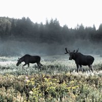
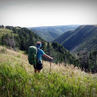
The West Coast Trail, originally called the Dominion Lifesaving Trail, is about a 75km long backpacking trail following the southwestern edge of Vancouver Island, British Columbia. It was built in 1907 to facilitate the rescue of survivors of shipwrecks along the coast, part of the treacherous Graveyard of the Pacific. It is now part of the Pacific Rim and is often rated by hiking guides as one of the world’s top hiking trails. The trail starts at Bamfield and runs south to Port Renfrew on Port San Juan Bay. You can choose to begin the trail in Port Renfrew and travel north, or in Bamfield and travel south. The southern parts of the trail are a bit more challenging than the flatter area in the north. You must buy a permit as only a set number of people are allowed to enter the trail at any one time. The trail itself winds through a beautiful rain forest, bogs, and beaches. It passes some very BIG trees, waterfalls, streams and thick patches of deep mud. To cross the larger rivers and streams hikers must ride cable car suspensions, while smaller or slower waterways are bridged by fallen logs or bridges. Wildlife that can be encountered include cougars, black bears, wolves, eagles, seals, sea lions and whales.
There are two waterways that require a boat to cross: the Gordon River, at the southern trailhead, and the Nitinat Narrows, near the midpoint of the trail. A ferry service is operated by the local First Nation. There are two locations on the trail where food can be bought; the ferry at Nitinat Narrows (km 32) has fresh seafood, a choice between salmon, halibut, and crabs, baked potatoes. Chez Monique’s on the beach (km 45), just south of the Carmanah Lighthouse, sells burgers, fresh fruit, and treats. Both locations also sell pop, Gatorade, and BEER.
We chose to travel North (Bamfield) to South (Port Renfrew) and had to take part in a mandatory orientation session prior to starting the trail. This is a very spectacular adventure that I recommend everyone experience. I would also not change a thing about our timeline. We have had fellow hiking friends complete the trail in under 5 days and each one of them really suggested that we extend our time on the trail and take in the beauty it has to offer. With this in mind, we really embraced the trail and stretched it over 7 nights. You have a chance to weigh your pack before you start and my start weight was 36lbs with Laura at 38lbs. I usually carry about 25lbs but had to account for 7 days of food which weighed about 12lbs. There are about 100 evacuations per year with 7 evacuations for our week. Hikers were evacuated because of sprains, fractures, and dislocations but a group also got evacuated because they had enough of this rugged adventure. Here is a recap of the days we spent on the trail from July 2nd to 9th, 2014.
Day 1: We took a 6 hour shuttle bus ride from Victoria to the northern trail head in Bamfield. We then sat through the park orientation and started hiking at 3pm. We hiked into the 14km Darling River tent site and arrived around 6pm to set up camp. Advice: Many people hike to Michigan site but we opted not to pitch here as it is more active being the first and last site on the trail.
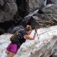
Day 2: We arrived before noon at Tsusiat Falls and were the only people there. We had the pick of sites and were able to find a site that provided some shade for this amazing 30degree hot day. Advice: it seems that the majority of hikers tend to congest and tent to the left as you enter the beach from the ladders. We camped on the opposite side of the waterfall and had plenty of room and what we think was the nicest site there.
Day 3: This was a bit longer day as it involved a river crossing by boat at Nitinat Narrows (km 32) and also involved a wonderful feed of fresh salmon and crab. We pitched at the 40km mark of Dare. On route we crossed through a closed section for camping because of cougar activity between 36km and 38km. Advice: We chose the earlier Dare as compared to Cribs as it was less busy. However; Cribs does look to be the nicer site. The whole experience with the ferry crossing at Nitinat Narrows took 2hrs so plan accordingly.
Day 4: We traveled 4km and had lunch with Chez Monique. This was a very pleasant experience. Chez Monique is a beach tarp restaurant located at km 45. Monique sold the most expensive burger that I have ever purchased at $25. Although it was one of the most heart warming, juicy, and delicious burgers I have ever eaten. On another note, my wife Laura has food sensitivities and has a gluten and lactose intolerance. Monique catered to Laura’s sensitivity and created a burger and salad option that rivaled any fancy restaurant. Monique also sells beer so I was able to get hydrated and refreshed. We were pleasantly surprised to find Monique sold bottles of wine. Laura and I purchased 2 bottles and traveled along the beach to Bonilla campsite, pitched and celebrated. We pretty much stopped hiking at noon and only traveled 8km this day. Advice: Take time to sit and enjoy the burger … you won’t regret it.
Day 5: We hiked to Cullite. This was my favorite day (even though we were soaked) as it involved some cable car crossings, a suspension bridge, and some very unsafe ladders. The past two days were wet / rainy so it made the conditions that much more challenging. We were happy to shut down, build a fire and get warm. Advice: Cullite is a nice site as there is woods cover to get out of the rain if need be.
Day 6: We left Cullite and headed to Camper as this was going to be our lunch spot. When we arrived at camper, the sun was shining and it was a beautiful day … so much that we decided to end our hiking day at noon once again and pitch for the night. This provided us the opportunity to unload all our gear in the sun and dry everything out after the past couple days rain. Advice: Great spot to freshen up and have a bath. Could get busy here as this is sometimes the last stop before heading out or the first stop for many as they start.
Day 7: We left camper and made our way to Thrasher via Beach Access A. Owen Point is a must see and we had a lot of fun running around the boulders. Advice: Camp high at Thrasher as the tide comes in very high and you don’t want to get wet.
Day 8: This involved a 2 hour hike out and across the Gordon River by ferry service. We then went to the Port Renfrew Hotel and had a real meal and a couple of beer.
Here are a few thoughts and tips for a safe and enjoyable hike:
- Take your time, stretch the trip out and enjoy the scenery …. you will appreciate it so much more.
- Although I ended up in the Mud quite a bit, Miss Laura completed the entire trip with only mud splatter while using little gaiters.
- There was lots of water along the trail so there is no need to carry more than 1L at a time.
- Keeping clean … we were able to bath every night as the accommodations allowed for this. There are some great bathing holes (Tsusiat, Campers, Cullite, etc) … But bath down steam and collect drinking water upstream. No one wants to drink ass water.
- Friendship … it is really neat how you connect with others on the trail. We met some really great people and enjoyed food, fire, and laughs with them. We will keep in touch and someday hopefully connect again. If you are in a rush, you may miss out on this special opportunity.
- Listen to peoples guidance but remember hikers have different abilities. We would have probably never left the trail head based on some of the feedback. A simple example for us is time and distance. I would consider us as active hikers and backpackers. For instance, what took many people all day, we shut down at early afternoon. People told us to not do the boulder section from campers to thrasher because it was so tough and unsafe when it was easy and one of the most beautiful sections of the trail. When we were on our last day, everyone was saying to plan for an hour to climb out of Thrasher Beach and a 5 hour hike out. It took us 15 minutes out of Thrasher and was to the trailed in under 2 hours after that. Plan to your skill level not what others do.

Pacific Rim Sign

Lush Trail like a Rain Forest

BIG Trees

MUD … I hate you!

most of the trail was like this

Cable Cars

Cable Cars, Suspension Bridges, Ladders

soooooooo many ladders

Coffee at the 14km Dare Tentsite

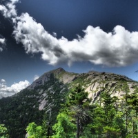
a beautiful Coastal View

Cougars, Bear Bin, Tsunami, mud

Tsusiat Falls … BEAUTIFUL

Lots of EAGLES

a RESTROOM with a view

Laura turned 42 years young and found a bridge numbered for her

Nitinat Narrows with Crab and Salmon

Chez Monique

Buoys mark the way

a special Laura Buoy was at our tent site

following the footsteps

Suspension bridge

ladders to get to suspension bridge

Wet … Wet … Wet

sun bathing at Camper Tent Site

Cave at Owen Point

a seat along the shore after Owen Point

Tenting at Thrasher Cove

a few shots of us

a few shots of friends along the way

… THE END