White Mountains, USA

Mount Baldface

Mount Baldface Map

Mount Baldface Map

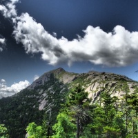
A significant portion of Mount Baldface is above treeline and Baldface’s ridge loop offers nearly continuous views in most directions, including a breathtaking view of Mt Washington looming above the Carter Range.

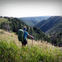
This is a fantastic loop hike with several fun stream crossings and a lot of views at the top of both peaks and along the ridge. As their name implies both peaks have bald summits and in some steep places you may find yourself on fun scrambles.  The Baldface Circle Trail makes a loop from the east over both peaks. Its two halves diverge at Emerald Pool about a mile from the trailhead. The southern part passes Chandler Gorge and the South Baldface Shelter, and includes a section of steep ledges on South Baldface. The trail follows the ridge from South Baldface to North Baldface, condinues north a short distance to Eagle Crag, and then drops down (short steep section right near the top) and returns to Emerald Pool. There is a noteworthy stream crossing just above Emerald Pool, and a smaller stream shortly above that. The complete loop is 9.8 miles, with about 3600 ft of elevation gain. (Elevation gain is about the same for any route.)

Categories: White Mountains, USA | Tags: , , , | 1 Comment

Mount Chocorua

Map of Mount Chocorua

Map of Mount Chocorua

Mount Chocorua is located in the white Mountains of New Hampshire. At an elevation of 3,490 feet (1,064 m) it is the easternmost peak of the sandwich range. Although the range is not outstanding for its elevation, it is very rugged and has excellent views of the surrounding lakes, mountains, and forests. Mount Chocorua’s bare summit can be seen from almost every direction and can be identified from many points throughout central New Hampshire and western Maine.

This is one of the most popular and beautiful hikes in the White Mountains of New Hampshire. Once you get up to the ridge via the steep ridge trail you will be following a ridge traverse over several rocky peaks to the summit of Chocorua.

Categories: White Mountains, USA | Tags: , , , | Leave a comment

Mount Washington via Huntington’s

We decided to return to our favorite mountains to vacation and hike with little Kasper this summer. Kasper is 14 and a half years old and full of health and energy and loves to hike. She has been hiking the White Mountains every summer with us since she was 6 months old when she submitted her first mountain. She even has a certificate and patch from the Appalachian Mountain Club (AMC) for summiting the forty eight 4000 footers in NH. We decided to have a basecamp and do day hikes with recovery days for Kasper (and ourselves). We started with our favorite hike up Mt. Washington on the Huntington Ravine trail and down the Tuckerman Ravine trail.  Kasper tore up the trail and hiked most of every trail upwards of 10 miles a day. We put her in our backpack whenever the boulders were too big and when the sun was too hot. Coming down Tuckerman’s we had to put her in our pack because we lost her leash and she was too fast for us to keep up. We were so happy to see her energy!!

Categories: White Mountains, USA | Tags: , , , , , | Leave a comment

Mount Adams and Mount Madison

We climbed up the Valley Way trail to Madison Spring Hut nestled between Mount Madison and Mount Adams. There are many hiking trails on the mountains. A stretch of the Appalachian Trail traverses just below the Mount Madison summit on the Osgood Trail. Mount Adams, elevation 5,793 feet above sea level, the second highest peak in the Northeast United States. Like most of the Presidential Range, the summits are above treeline. Due to high winds and low temperatures, hypothermia is a danger even in the summer. The Randolph Mountain Club (RMC) maintains the trails and several huts and shelters high on Mount Adams’ north side, including “The Perch” … we love staying here. A large network of hiking and climbing paths lead south to the huts and ridges from several parking areas located on US Hwy #2.

On our decent we took a new to us trail … The Chemin Des Dames trail just off of the Airline trail descending from Mt. Adams. It is a short trail at only 1/2 mile long but it was a somewhat steep climb down over boulders and over loose rocks. It’s a classic Presidential Range sort of hike.

Categories: White Mountains, USA | Tags: , , , | Leave a comment

Lion’s Head Trail

After completing Huntington’s Ravine Trail and crossing over Mt. Washington’s summit we decided to descend by route of the Lion’s Head Trail.  The Lion’s Head Trail is about the same length as the Tuckerman’s Ravine trail but it is steeper and rougher.  In exchange you get better views and less crowds.

Categories: White Mountains, USA | Tags: , , , | Leave a comment

Huntington’s Ravine Trail

Huntington Ravine is a glacial cirque on Mount Washington in the White Mountains of New Hampshire.  This is our favorite route to Washington’s Summit.  It has the steepest and highest headwall, crosses a boulder field, ascends a collection of broken rock fragments (scree) at the base of a cliff.  Avalanches, icefalls, and hypothermia have killed climbers in Huntington repeatedly in recent years, and the hiking path is usually not passable until late May or early June.

This slideshow requires JavaScript.

Categories: White Mountains, USA | Tags: , , , | Leave a comment

Franconia Notch (Flooded)

franconia notch mapLaura, Kasper, and I returned to the White Mountains of New Hampshire for our CANADA Day celebrations.  We decided to start our hiking with a traverse along the Franconia Notch.  This is a major mountain pass dominated by Cannon Mountain to the west and Mount Lafayette to the east.  This should take a couple days to complete and then we would continue on to do the Presidential Range.  We started late (3pm) on Sunday, June 30 and decided to climb from trail head to overnight at Liberty Spring Tent site.  We had a great night at Liberty and hit the trail early on CANADA Day Monday as we had a tough 21km trek before our next planned tent site of Guyot.  Unfortunately weather reports were taking a turn for the worse and at 1pm we had to shut it down as Thunder and Lightning were in our near future.  Being above treeline on a mountain ridge is not the place you want to be in a lightning storm.  This really changed our plans and we were only able to complete half of our planned distance.  We bunked down in our tent at the Garfield tent site.  That evening was the most rainfall I have ever experienced.  Reports for over night rainfall amounts were close to 4 inches.  Since we are on a mountain, all the rainfall above us … ran into us.  This was a major amount of water and it completely changed our agenda.  Water was now everywhere, the Appalachian Trail was now a waterfall, and brooks turned into rivers.

Based on how things were stacking up, we decided to bail and plan an escape route and head back up in a couple days after things dry out.  Having to stop early put us behind by 10km, and we would have to make up more ground in slow tough conditions.  Our 2 day plan through the Franconia Notch linking into a 3 day plan through the Presidential Range took a major detour.  We heard on the news of a few deaths in the area because of the tough conditions.  One lady drowned crossing a river and another was swept away without being found.  A fisherman also drowned as he was swept off his feet.

Here are a few pictures from our Franconia Notch Traverse from Liberty Spring Trail to Galehead Hut.

This slideshow requires JavaScript.

Categories: White Mountains, USA | Tags: , , , | 1 Comment

day hiking the Whites

Laura, Kasper and myself had a runaway weekend to do some hiking in the White Mountains.  It was Miss Laura’s birthday on July 6th and she wanted to be on top of a mountain.  Saying that, we climbed the hardest trail (Huntington Ravine) to summit Mount Washington.  This was a great day, and we did a little hiking on the days that following.  We just love New Hampshire’s White Mountains.

This slideshow requires JavaScript.

Categories: White Mountains, USA | Tags: , , | 1 Comment

New Hampshire, USA

Laura, Kasper, and I spent the end of July and first part of August doing some hiking and backpacking in the White Mountains of New Hampshire, USA.  Lots of fun, beautiful weather and loads of Laughs.

This slideshow requires JavaScript.

Categories: White Mountains, USA | Tags: | Leave a comment

4000 footers completed

we started our journey towards the goal of becoming one of the elite members of the official AMC 4000 footer club.  A group consisting of members who have climbed their list of New Hampshire’s White Mountain National Forest 48 x 4000 footer summits.  We had some rough times (like weather chill classed as minus 18 in August, and 100km winds), fun times, and lots of sore mussels.  We continue to enjoy the whites and all the beauty it provides.  Here some of our memorable photos:

This slideshow requires JavaScript.

Categories: White Mountains, USA | Tags: , , | Leave a comment

Blog at WordPress.com.

Misadventures In The Wild

Adventuring and misadventuring around Nova Scotia and beyond.

Welcome to MAMATREK

Hiking in the White Mountains of New Hampshire

The Mountain Blog

"life isn't measured by the number of breaths you take, but by the number of moments that take your breath away"

Never Stop Exploring

"life isn't measured by the number of breaths you take, but by the number of moments that take your breath away"

"life isn't measured by the number of breaths you take, but by the number of moments that take your breath away"

Corey's Adventure Journal (hiking & backpacking)

"life isn't measured by the number of breaths you take, but by the number of moments that take your breath away"

I Luv 2 Fish

Some men would rather be photographed with their Fish than their Wives . . .